



Terrain & canopy
Create terrain, surface and canopy-height grids, then inspect height, cover and return-density products.
A browser-based research environment
Inspect point clouds, measure forest structure and compare acquisitions in one browser workspace.
PRISM runs entirely online, requires no installation, and is accessible through modern web browsers across major operating systems.
Version 2.3 Research preview
Project origins
PRISM was initiated through the U.S. Forest Service Partnership for Remote Inventory and Stand Management (PRISM) project in September 2021.
A real-data starting point
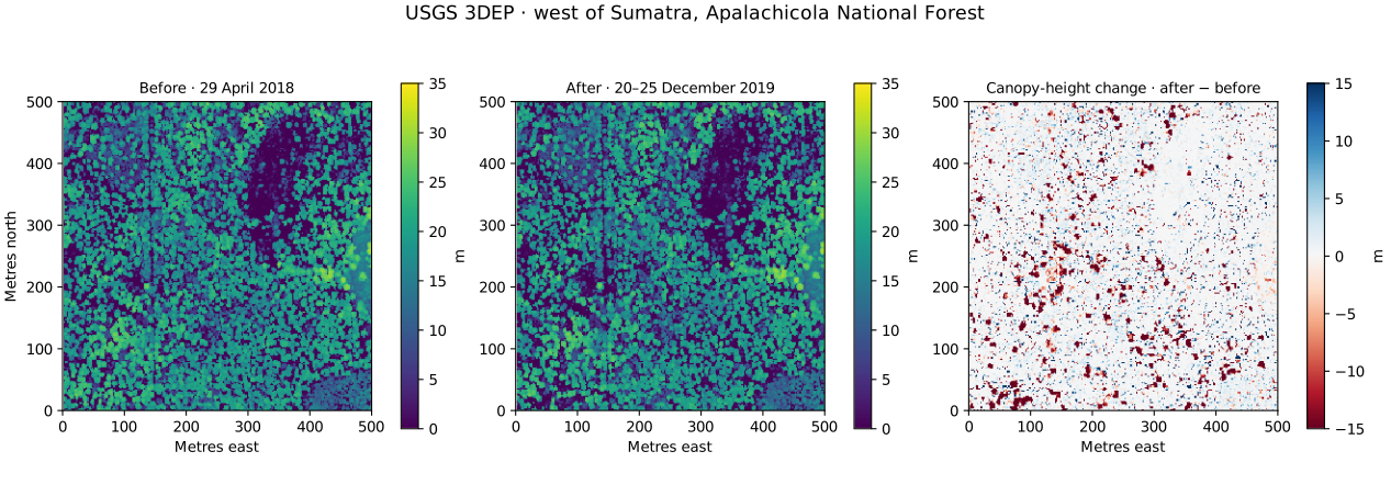
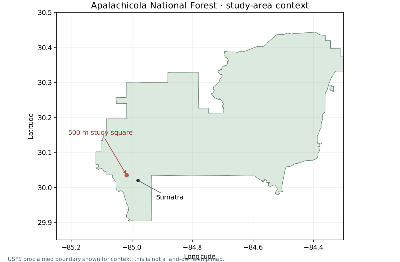
Explore the Hurricane Michael study landscape west of Sumatra, in Apalachicola National Forest, with measured USGS 3DEP returns and a shared analysis grid.
Work through the example
Use the point viewer to examine returns, review terrain and canopy products, and compare the two dates. Read the original acquisition references before interpreting the difference.
The prepared example makes the workflow visible on arrival. A local rerun retrieves and processes the accepted source returns; a point-preview sample is never substituted for those metrics.
Follow the step-by-step manualThe current toolset
Maps, point inspection, raster analysis and GIS-ready outputs share one professional workspace.
Create terrain, surface and canopy-height grids, then inspect height, cover and return-density products.
Review declared percentiles, mean, sample variation and return-based cover with explicit height thresholds.
Detect canopy peaks, inspect approximate crown regions and exact pixel-support polygons, and colour matching point previews.
Process two or three sources on a shared grid, review comparability and calculate later-minus-earlier products.
Process buffered windows to a local folder and resume work from verified, checksummed completed tiles.
Save rasters, cell tables, tree vectors, AOI and provenance that identify data sources, units, settings and method versions.
A numbered starting workflow
The compact workflow strip keeps the common path visible while retaining advanced controls.
Advanced controls remain available for metric settings, source reprocessing, individual-tree parameters, tiled jobs and individual exports. The suite orchestrates current capabilities; it does not add unimplemented fire/fuels models or establish reference-tool parity.
Open the numbered workflowA traceable workflow
Review source references and parameters before computing. Keep the exported provenance beside the products you use.
EPT hierarchy levels and COPC ranges are selected spatially. Returns are decoded locally and clipped to the exact study polygon within explicit resource budgets.
The workspace opens in modern browsers. Large tiled jobs need desktop Chrome or Edge features for directory access and locks. Browser/device checks describe available capabilities.
Current outputs use preliminary declared definitions. Source alignment, vertical reference, acquisition conditions and field context determine how a result can be interpreted.
Research preview
Implementation, engineering verification and scientific validation are tracked separately.
Area metrics, canopy-peak/crown analysis, exact-grid differences, buffered tiling, export and provenance are available within documented limits.
Vertical strata, qualified ladder-fuel indicators and calibrated fuel models are future work. Current structure products do not estimate fuel mass or fire spread.
Independent numerical engineering checks cover declared definitions and selected real datasets. FUSION/lidR parity and field accuracy remain separate acceptance work.
Release & attribution
Record the software version alongside the original acquisition, method definitions and analysis settings.
Broadbent, E. N., Drake, J. B., Medley, P., & Almeyda Zambrano, A. M. (2026). PRISM: A browser-based, cross-platform environment for LiDAR and remote-sensing analysis (Version 2.3) [Computer software]. https://prismlidar.app
Developed with support from the Apalachicola Regional Restoration Initiative (ARRI) and the Partnership for Remote Inventory and Stand Management (PRISM) of the U.S. Department of Agriculture, Forest Service and SPECLab internal research funds. Portions of the software development and documentation were completed with assistance from AI tools under the direction of the PRISM development team. The team is responsible for reviewing and verifying these contributions. Validation status and remaining limits are described in the Methods. Development continues with support through ARRI and SPECLab internal research funds.